 Wersja polska
 English version
Wawrzaszek A., Krupiński M., Aleksandrowicz S., Drzewiecki W.: Formalizm multifraktalny w analizie zobrazowań satelitarnych. Archiwum Fotogrametrii, Kartografii i Teledetekcji, vol. 25, s.261–272, 2013
W pracy przedstawiamy formalizm multifraktalny, jako narzędzie wspomagające opis i ekstrakcję informacji z wysokorozdzielczych zobrazowań satelitarnych. Podejście to opiera się na założeniu, że na pojedynczy obraz (multifraktal) składa się wiele fraktali, każdy o innym
Drzewiecki W., Wawrzaszek A., Krupiński M., Aleksandrowicz S., Bernat K.: Comparison of selected textural features as global content-based descriptors of VHR satellite image – the EROS-A study. 2013 Federated Conference on Computer Science and Information
Texture is considered as one of the most crucial image features used commonly in computer vision. It is important source of information about image content, especially for single-band images. In this paper we present
Stelmaszczuk, M. & Wołk-Musiał, E. (2009). Image enhancement within assessment of usefulness of Landsat thermal-infrared images for geological application. Remote Sensing of Environment, 39, 48-58
The main object of the research was to assess usefulness of Landsat TM thermal infrared images for geological application. Within the assessment special steps of enhancement of illegible image were implemented. On the first
Sedo, P., Diaz, R., Gracia, V., Romero, L., Piolle, J.F., Kerbaol, V., Michail, A., Pittam, N., Kitson & Stelmaszczuk, M. (2009). PEARL – Environmental Management System for Port Authorities. Archive of Photogrammetry, Cartography and Remote Sensing
The PEARL system is a tailor-made platform based on a modular structure which provides an Environmental Management System for Port Authorities that allows the incorporation of future data sources (new in-situ sensors, future space
Stelmaszczuk, M., Drzewiecki, W. & Bielecki, M. (2010). Capacity building in the usage of spatial information – proposition of the specialized geoportal. Annals of Geomatics of the Polish Association for Spatial Information, 6, 42, 121–130
The Earth Observation sector evolves rapidly. This fact provides motivation for organisations from all over the world to undertake different initiatives and programs aimed at improving the management of EO resourses. One of them
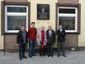
IV Space Conference in Sieradz
On 8-9 October 2013 in Cultural Center in Sieradz held IV Space Conference “Heritage Arego Sternfeld. Earth as seen from outer space.”. This conference was organized in honor of Arego Sternfeld- one of the
EOPOWER: Earth Observation for Economic Empowerment
The purpose of the EOPOWER project is to create conditions for sustainable economic development through the increased use of Earth observation products and services for environmental applications. This purpose serves the higher goal of
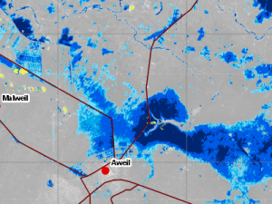
Crisis Information Centre in fight against floods in South Sudan
As every year since August until October, the area surrounding rivers Lol and Jur in South Sudan is visited by floods caused by torrential rainfalls that occurs during the rainy season. The swollen rivers
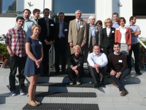
Polish-Ukrainian seminar
Earth Observation Group as part of the EOPOWER project, has organized a seminar, which was attended by representatives of scientific institutions and NGOs from Poland and Ukraine, i.e. Scientific Centre for Aerospace Research of
Aleksandrowicz S., Stelmaszczuk M., Bochenek Z., Lewiński S., Turlej K., Groom A., Metz A., Esch T., Gurova E., Vaitkus G., 2010. “Seasonal & Annual Change Monitoring” in Photonics Applications in Astronomy, Communications, Industry, and High-Energy Physi
Seasonal & Annual Change Monitoring (SATChMo) is one of the Core Mapping Services within the geoland2 project. The project is co-founded by the European Commission under the 7th Framework Program in the Space Activity