
 The rapid development of the satellite systems and airborne measurements generates significant increase of the amount of collected observational data about our planet. This forces the improvement of existing and the development of new methods for collecting, processing and analysis of multidimensional remotely sensed images.
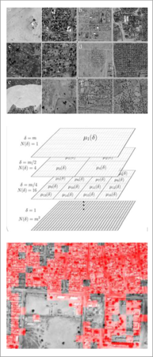
Multifractals is the concept which in our opinion creates great opportunities of the description and extraction of information from many experimental data, also from the remote sensing data. Multifractal approach is based on the assumption that to describe the complexity of the data is necessary to use a number of non-trivially connected fractal, each with a different dimension of self-similarity. What is more, with multifractal description many functions and quantitative parameters are connected. Usefulness of these characteristics in the context of the remote sensing data processing has not been fully tested so far.
The main objective of this project is related to the presented issues and concerns the development of multifractal description of remote sensing images, as well as the evaluation of its applicability in the selected aspects of processing and analyzing of satellite and aerial optical data. More precisely, in the frame of the project we are planning: (I) change detection on high and very high spatial resolution satellite images; (II) analysis of image information capacity and detection of absorption bands on hyperspectral data; (III) classification of the selected land cover forms. We are planning to perform our analysis on large optical data sets, acquired by satellite and aerial sensors. Moreover, we want to compare the usefulness of multifractal formalism with mathematical morphology.
We are convinced that these studies may be important in the aspect of dimensionality reduction of hyperspectral data (without the loss of information). We also believe that the multifractal description will allow for further development of multifractal change detection approaches and would improve classification accuracy of land covers forms. It is worth to underline that the research which we planned within this project will bring significant development of multifractal description of image content and will help to develop approaches relevant for remote sensing data analysis and other disciplines related to image processing.
Research supported by the Polish National Science Centre (NCN) through grant 2016/23/B/ST10/01151