
2021:
 Aleksandrowicz S., Wawrzaszek A., Drzewiecki W., Krupiński M., Jenerowicz M., "Change Detection in Multispectral VHR Images Using Spatialized Hölder Exponent" in IEEE Geoscience and Remote Sensing Letters
Multifractals have proven to be a valuable tool in image analysis applications and remote sensing (RS). They can be used for image segmentation, texture analysis, and classification. This study explores their applicability to change detection. We present a new approach to image texture description based on the calculation of a spatialized Hölder exponent on multispectral satellite data. Hölder exponents are evaluated in the context of an unsupervised change detection algorithm, and the classification of change in various land cover classes. Obtained results show that the sensitivity of proposed methods varies from 69% up to 93% with a considerably low level of false alarms.
 Wawrzaszek A., Drzewiecki W., Krupiński M., Jenerowicz M., Aleksandrowicz S., "Multifractal Features for Land Use Classification" in IGARSS 2020 – 2020 IEEE International Geoscience and Remote Sensing Symposium, Waikoloa, HI, USA, 2020
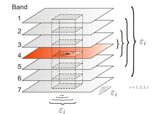
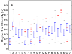
In our work, we analyze multifractal parameters for the description and classification of a 2056 subsets of aerial images representing 21 land-use classes. In particular, we consider the degree of multifractality, estimated with different capacity measures, as global features characterizing the texture on considered image tiles. Results show that the degree of multifractality designated for particular tiles differs slightly between spectral bands, and reveal some dependence on land-use classes. Moreover, we show that based on multifractal parameters used together with histogram features it is possible to classify the used UC-Merced dataset with a satisfactory level of accuracy. The conducted analysis shows that multifractal features provide additional input for global characterization and automatic classification of aerial images.
 Krupiński M. Wawrzaszek A., Drzewiecki W., Jenerowicz M., Aleksandrowicz S., "Multifractal Parameters for Classification of Hyperspectral Data" in IGARSS 2020 – 2020 IEEE International Geoscience and Remote Sensing Symposium, Waikoloa, HI, USA, 2020
(Multi)fractal character of hyperspectral imagery allows for application of new methods and parameters for data processing. In this work we apply Multifractal Detrended Fluctuation Analysis to describe the complex shape of spectral curve and to use determined parameters as the classification features. Working on three publically available datasets, we analyze the usefulness of the six multifractal parameters in the context of land cover / land use classification using machine learning classifier. Moreover we examine different approaches for data preprocessing and their influence on classification results.
2020:
 Krupiński M., Wawrzaszek A., Drzewiecki W., Jenerowicz M., Aleksandrowicz S., "What Can Multifractal Analysis Tell Us about Hyperspectral Imagery?" in Remote Sensing, vol. 12, no. 24, 2020
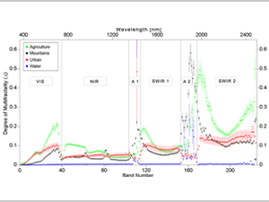
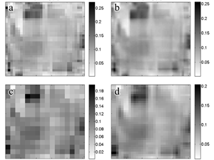
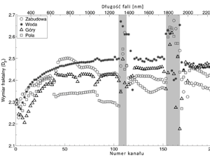
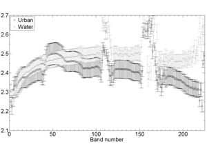
Hyperspectral images provide complex information about the Earth’s surface due to their very high spectral resolution (hundreds of spectral bands per pixel). Effective processing of such a large amount of data requires dedicated analysis methods. Therefore, this research applies, for the first time, the degree of multifractality to the global description of all spectral bands of Airborne Visible/Infrared Imaging Spectrometer (AVIRIS) data. Subsets of four hyperspectral images, presenting four landscape types, are analysed. In particular, we verify whether multifractality can be detected in all spectral bands. Furthermore, we analyse variability in multifractality as a function of wavelength, for data before and after atmospheric correction. We try to identify absorption bands and discuss whether multifractal parameters provide additional value or can help in the problem of dimensionality reduction in hyperspectral data or landscape type classification.
 Belcore E., Wawrzaszek A., Woźniak E., Grasso N., Piras M., "Individual Tree Detection from UAV Imagery Using Hölder Exponent" in Remote Sensing, vol. 12, no. 15, 2020
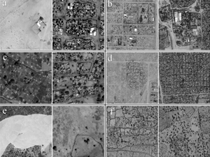
Land Cover (LC) plays a key role in many disciplines and its classification from optical imagery is one of the prevalent applications of remote sensing. Besides years of researches and innovation on LC, the classification of some areas of the World is still challenging due to environmental and climatic constraints, such as the one of the mountainous chains. In this contribution, we propose a specific methodology for the classification of the Land Cover in mountainous areas using Sentinel 2, 1C-level imagery. The classification considers some specific high-altitude mountainous classes: clustered bare soils that are particularly prone to erosion, glaciers, and solid-rocky areas. It consists of a pixel-based multi-epochs classification using random forest algorithm performed in Google Earth Engine (GEE). The study area is located in the western Alps between Italy and France and the analyzed dataset refers to 2017-2019 imagery captured in the summertime only. The dataset was pre-processed, enriched of derivative features (radiometric, histogram-based and textural). A workflow for the reduction of the computational effort for the classification, which includes correlation and importance analysis of input features, was developed. Each image of the dataset was separately classified using random forest classification algorithm and then aggregated each other by the most frequent pixel value. The results show the high impact of textural features in the separation of the mountainous-specific classes the overall accuracy of the final classification achieves 0.945.
2019:
 Jenerowicz M., Wawrzaszek A., Drzewiecki W., Krupiński M. Aleksandrowicz S., "Multifractality in Humanitarian Applications: A Case Study of Internally Displaced Persons/Refugee Camps" in IEEE Journal of Selected Topics in Applied Earth Observations and Remote Sensing, vol. 12, no. 11, pp. 4438-4445, Nov. 2019.
The coordination of humanitarian relief is always difficult due to a lack of data required for management and planning. Remote sensing imagery can be an important source of information about the in-situ situation, notably, no-access areas. Scenarios include situation awareness after natural disasters or military conflicts, damage assessment, or monitoring camp structure, either as a one-off exercise or on an ongoing basis. In this article, we propose a multifractal approach to automating information extraction about internally displaced persons/refugee camps and discuss its potential and limitations. Our case study uses multifractal features to determine the extent of camps in Kenya and Sudan. The results show that the method can be usefully applied to camp growing analysis and help to make a rough, but rapid estimation of their extent. Our multifractal method appears to be a reasonable step forward on the road between manual mapping and (not yet developed) fully automated, highly accurate processing.
 Drzewiecki W., Wawrzaszek A., Krupiński M., Aleksandrowicz S. Jenerowicz M., "Multifractal Parameters in Prediction of Land-use Components on Satellite Images," 2019 Signal Processing: Algorithms, Architectures, Arrangements, and Applications (SPA), Poznan, Poland, 2019, pp. 296-301.
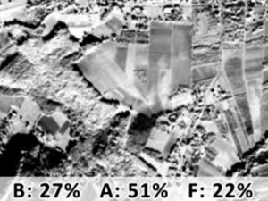
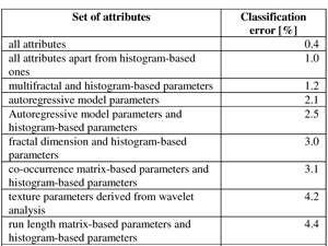
The aim of the study was to assess the usefulness of multifractal parameters as global features describing the content of very high-resolution satellite images. It was done in a research experiment aiming at prediction of basic land-use classes shares within the image tiles cut from satellite EROS-A images. The reference land use data were obtained by on-screen digitizing of aerial ortophotomaps. The shares of built-up areas, agriculture areas and forests in the area of every image tile (ca. 1 sq. km) were calculated. Image tiles were also characterized using wide set of selected global textural features. Apart from multifractal parameters and fractal dimension we used histogram-based features as well as parameters based on cooccurrence matrix, run length matrix, absolute gradient, autoregressive model and wavelet analysis. The Cubist algorithm was applied to predict the percentages of each land use class within the image tiles. The results were evaluated using RMSE, MAE and R squared. When particular groups of textural parameters are considered, the best results in our experiment were obtained for absolute gradient-based features and multifractal features. The outcomes of presented study confirmed our previous findings that multifractal parameters should be considered as useful descriptors of high-resolution satellite image content.
 Jenerowicz M., Wawrzaszek A., Krupiński M., Aleksandrowicz S., and Drzewiecki W. (2019), Comparison of mathematical morphology with the local multifractal description applied to the image samples processing, Proc. SPIE 11176, Photonics Applications in Astronomy, Communications, Industry, and High-Energy Physics Experiments 2019, 1117638 (6 November 2019)
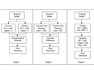
This paper presents the results of a preliminary comparison of two methods which are based on the mathematical approach, Mathematical Morphology and the Local Multifractal Description. Both methods are characterized by the need for input parameters defining. Those parameters are engaged in the model development, allowing to study the objects presented on the images in respect to the intended purpose of the analysis. Due to the initial visual interpretation and image objects descriptors definition, both methods are considered as a semi-automatic. Tests were performed based on the selected Brodatz textures and artificially generated noisy images, aiming at the indication of strong and weak points of both methods while applied to the edge/object detection tasks.
 Aleksandrowicz S., Wawrzaszek A., Jenerowicz M., Drzewiecki W. and Krupiński M. (2019), Local Multifractal Description of Bi-Temporal VHR Images, 2019 10th International Workshop on the Analysis of Multitemporal Remote Sensing Images (MultiTemp), Shanghai, China, 2019, pp. 1-3
In this work we apply local multifractal formalism to spectral bands of bi-temporal Very High Resolution (VHR) images. Analysis of the local multifractal description and its changes between images acquired in two points in time can be used to extract changes in the urban areas.
 Jenerowicz M., Wawrzaszek A., Krupiński M., Drzewiecki W., Aleksandrowicz S. (2019), Aplicability of Multifractal Features as Descriptors of the Complex Terrain Situation in IDP/Refugee Camps, IGARSS 2019 – 2019 IEEE International Geoscience and Remote Sensing Symposium, Yokohama, Japan, 2019, pp. 2662-2665.
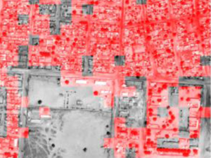
This paper presents the preliminary results of the complex terrain situation description with the utility of multifractal features. The analysis was done for two samples of Internally Displaced Person/Refugee camps (Ifo, Daadab in Kenya/Al Geneina in Sudan). In both cases, the information on the complex terrain situation was derived based on the Very High Resolution (VHR) satellite panchromatic images. The multifractal formalism was applied in order to evaluate the scope of multifractal features applicability in the image classification domain. The results show, that the multifractal parameter calculated for all considered parts of the scenes increases in the area of compact image structures. This study gives a promising aspect of limited calculation time needed for the initial stage of image classification in respect to the spatial complexity of analysed terrain.
 Krupiński M., Wawrzaszek A., Drzewiecki W., Aleksandrowicz S., Jenerowicz M. (2019), Multifractal Parameters for Spectral Profile Description, IGARSS 2019 – 2019 IEEE International Geoscience and Remote Sensing Symposium, Yokohama, Japan, 2019, pp. 1256-1259.
Hyperspectral data provides huge amount of detailed information about spectral properties of the objects. In the era of fast data volume enlargement, it is necessary to develop methods and algorithms which are capable for information extraction from Big Data. On the other hand, plenty of phenomena observed on Earth reveal (multi)fractal character or properties. In our work, we focus on application of multifractal formalism for remote sensing data analysis. In this paper, we present an example of multifractal parameters estimation for aerial hyperspectral dataset analyses. We have applied the Multifractal Detrended Fluctuation Analysis (MDFA) for spectral signatures description. Two main aspects of this work contain different strategies for multifractal parameters estimation and assessment of multifractal features usability in the context of hyperspectral image classification.
2016:
 Aleksandrowicz S., A. Wawrzaszek, W. Drzewiecki, M. Krupiński, 2016. Change Detection Using Global and Local Multifractal Description, in IEEE Geoscience and Remote Sensing Letters, vol. 13, no. 8, pp. 1183-1187, doi: 10.1109/LGRS.2016.2574940.
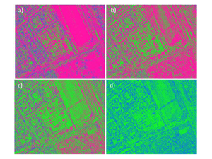
In this letter, we apply the multifractal formalism to land cover change detection on very high spatial resolution data. Specifically, multifractal spectra are determined and, with modifications, are used as an initial general indicator of change on the subsets of IKONOS and Pleiades images. Next, we calculate Hölder exponents for each pixel in the images and use them to generate a change mask. Our analysis shows that Hölder exponents enable a detailed evaluation of changes in land cover. A comparison with change detection based solely on panchromatic images shows that the multifractal description method has significant advantages as it reduces the number of false positives. In addition, we show that our change detection results are comparable with other multiscale techniques.
 Drzewiecki W., A. Wawrzaszek, M. Krupiński, S. Aleksandrowicz, K. Bernat, 2016. Applicability of multifractal features as global characteristics of WorldView-2 panchromatic satellite images, European Journal of Remote Sensing, vol. 49, pp. 809 – 834, doi: 10.5721/EuJRS20164943.
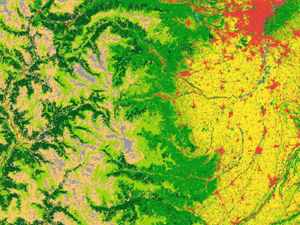
In this work we analyse fractal and multifractal characteristics for description and extraction of information from VHR satellite images. We propose the degree of multifractality as a global descriptor of satellite image content and investigate its usefulness for classification of WorldView-2 image chips into main land cover types. The research confirmed that it is possible to use the textural features as efficient global descriptors of WorldView-2 panchromatic image content. Results show that the degree of multifractality is related to land cover type prevailing in the imaged area. It was also proved that multifractal parameters should be considered as valuable textural features in the context of land cover classification.
2015:
 Wawrzaszek, A., M. Walichnowska, M. Krupiński, 2015. Ocena przydatności poziomu multifraktalności do opisu wysokorozdzielczych danych pozyskanych przez satelity LANDSAT, Archiwum Fotogrametrii, Kartografii i Teledetekcji, vol. 27, s. 175-184 ISSN 2083-2214, eISSN 2391-9477, doi: 10.14681/afkit.2015.013.
In the frame of this work six satellite images (at six spectral bands) from Landsat 5, Landsat 7 and Landsat 8 have been analysed. For this purpose 30 meter resolution images showing the regions of Warsaw have been used. The conducted research allowed for verification if the whole scene presents multifractal features and if size of the division of the scene used during the analysis has a significant influence on the multifractal characteristic and error in their calculation. Initial interpretation of the obtained results showed, that the use of degree of multifractality determined for remote sensing data with the 30 meters resolution does not reveal direct relation with land cover classes. It should be noted, however, that the considered data have not been the subject of a previous processing, which according to the discussion performed in this work can be considered as one of the methods to achieve an improvement in results.
 Wawrzaszek, A., M. Krupiński, W. Drzewiecki, S. Aleksandrowicz, 2015. Multifraktalna analiza zobrazowań satelitarnych, Archiwum Fotogrametrii, Kartografii i Teledetekcji, vol. 27, s. 163-173, ISSN 2083-2214, eISSN 2391-9477, doi: 10.14681/afkit.2015.012.
Research presented in this paper is focused on the efficiency assessment of multifractal description as a tool for Image Information Mining. Large datasets of very high spatial resolution satellite images (WorldView-2 and EROS-A) have been analysed. The results have confirmed the superiority of multifractals as global image descriptors in comparison to monofractals. Moreover, their usefulness in image classification by using decision trees classifiers was confirmed, also in comparison with textural features. Filtration process preceding fractal and multifractal features estimations was also proved to improve classification results. Additionally, airborne hyperspectral data have been initially analysed. Fractal dimension shows high potential for the description of hyperspectral data. To summarise all conducted tests indicate the usefulness of multifractal formalism in various aspects of remote sensing. Prepared methodology can be further developed and used for more specific tasks, for example in change detection or in the description of hyperspectal data complexity.
2014:
 Pyka K., W. Drzewiecki, K. Bernat, A. Wawrzaszek, M. Krupiński, 2014. Usefulness of wavelet-based features as global descriptors of VHR satellite images. Proc. SPIE 9244, Image and Signal Processing for Remote Sensing XX, 92441D (October 13, 2014); doi:10.1117/12.2067323.
In this paper we present the results of research carried out to assess the usefulness of wavelet-based measures of image texture for classification of panchromatic VHR satellite image content. The study is based on images obtained from EROS-A satellite. Wavelet-based features are calculated according to two approaches. In first one the wavelet energy is calculated for each components from every level of decomposition using Haar wavelet. In second one the variance and kurtosis are calculated as mean values of detail components with filters belonging to the D, LA, MB groups of various lengths. The results indicate that both approaches are useful and complement one another. Among the most useful wavelet-based features are present not only those calculated with short or long filters, but also with the filters of intermediate length. Usage of filters of different type and length as well as different statistical parameters (variance, kurtosis) calculated as means for each decomposition level improved the discriminative properties of the feature vector consisted initially of wavelet energies of each component.
 Wawrzaszek, A., S. Aleksandrowicz, M. Krupiński, W. Drzewiecki, 2014. Influence of Image Filtering on Land Cover Classification when using Fractal and Multifractal Features, Photogrammetrie Fernerkundung Geoinformation, 2014 / 2, 101–0115. doi: 10.1127/1432-8364/2014/0212.
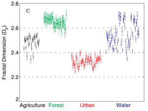
Over the last years, many features describing satellite images have been proposed. In this paper we analyse and compare fractal and multifractal features in the context of the discrimination of the four most common land cover classes on very high resolution optical satellite images. In particular, we consider agricultural, forest, urban and water classes from WorldView-2 scenes and for their global description we propose to use the “degree of multifractality”. We focus on the verification if the image filtration prior to the calculation of fractal and multifractal parameters may improve their efficiency as image content descriptors. In order to evaluate the effectiveness of the coupling of fractal and multifractal features with the image filtration we analyse the class separability measures and the classification accuracy. Our study results indicate that the degree of multifractality improves the classification accuracy in comparison to the fractal dimension.
 Krupiński M., A. Wawrzaszek, W. Drzewiecki, S. Aleksandrowicz, 2014. Usefulness of the fractal dimension in the context of hyperspectral data description. W: SGEM 2014: GeoConference on Informatics, geoinformatics and remote sensing: international multidisciplinary scientific geoconference : 17–26 June, 2014, Albena, Bulgaria : conference proceedings. Vol. 3, Photogrammetry and remote sensing cartography and GIS. — Sofia: STEF92 Technology Ltd., 367-374.
The number of hyperspectral sensors and data grows systematically and dynamically. Hyperspectral data delivers huge number of precise information but character of data requires specific methods of processing. One of these methods can be the use of the fractal description. In literature there are only a few attempts to analyze hyperspectral images using fractal parameters. Most of them concern on measuring fractal dimension of spectral signatures corresponding to the single pixels. The second group focuses on describing every hyperspectral image channel by fractal parameter. In this research we verify the fractal dimension usability for hyperspectral channels description. In order to calculate the fractal dimension we use the Differential Box- Counting method which is accurate and computationally efficient. We analyze the variability of fractal dimension calculated for hyperspectral image channels for two types of data – the radiance and the reflectance. The data we use has been acquired by AVIRIS sensor; designed and developed in Jet Propulsion Laboratory. Analyzed data include 224 channel images of solar reflected spectrum from 400nm to 2500nm and present homogenous land cover classes (water, mountains, agriculture and urban areas), as well as heterogeneous samples. Conducted analysis show advantages and limitations of the fractal parameter as a channel content descriptor. In particular, we observe that different land cover classes may be categorized basing on fractal dimension values of channels from specific parts of electromagnetic spectrum where values fluctuations are observed. Only water sample presents stable behavior of fractal dimension. For individual land cover class we observe differences between fractal dimension of radiance and reflectance data mainly for visible part of electromagnetic spectrum. Moreover, in cases of radiance data, irregularities of fractal parameter values indicate noisy channels. Summarizing, fractal dimension values seem to be useful as the channel quality measure and information capacity measure. Moreover, it could be used for noisy channels discrimination, usability estimation, different land cover classes categorization or atmospheric correction quality estimation.
2013:
 Drzewiecki, W., A. Wawrzaszek, S. Aleksandrowicz, M. Krupiński, K. Bernat, 2013. Comparison of selected textural features as global content-based descriptors of VHR satellite image, Geoscience and Remote Sensing Symposium (IGARSS), 2013 IEEE International, 4364 – 4366, doi: 10.1109/IGARSS.2013.6723801.
The paper presents the results of the study of usefulness of selected textural features for describing the content of image chips (1024 by 1024 pixels) cut from WorldView-2 panchromatic images. Several texture analysis techniques were applied to calculate 290 different global image descriptors. These features together with 4 histogram-based characteristics formed the set of classification features. Decision trees were used to classify the images into broad land cover categories. Performance of each group of textural characteristics was assessed and compared to the results of classification based on all calculated characteristics.
 Wawrzaszek A., M. Krupiński, S. Aleksandrowicz, W. Drzewiecki, 2013. Fractal and multifractal characteristics of very high resolution satellite images, Geoscience and Remote Sensing Symposium (IGARSS), 2013 IEEE International, 1501 – 1504, doi:10.1109/IGARSS.2013.6723071.
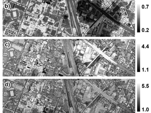
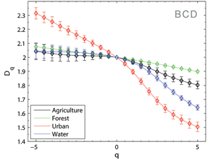
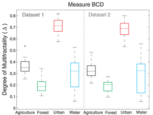
In our work we analyse fractal and multifractal characteristics for description and extraction of information from very high spatial resolution satellite images. In particular, we propose the degree of multifractality as a parameter for extraction of four land cover types and investigate its usefulness in comparison with the fractal dimension. Results show that degree of multifractality designated for individual fragments of images differs depending on the present land cover type. The highest multifractality level is observed for urban area, the lowest for water, which can be treated as a monofractal. In general multifractal parameter allows for automatic assignment of land cover types to specific classes. Some deviations take place in case of discrimination between agricultural areas and forests. This problem is also considered by using additional measures during the process of multifractal parameter computation. Conducted analysis shows that multifractal formalism creates additional possibilities for the description and automatic classification of satellite images.
 Drzewiecki, W., A. Wawrzaszek, M. Krupiński, S. Aleksandrowicz, K. Bernat, 2013. Comparison of selected textural features as global content-based descriptors of VHR satellite image - the EROS-A study. 2013 Federated Conference on Computer Science and Information Systems, 43-49.
Texture is considered as one of the most crucial image features used commonly in computer vision. It is important source of information about image content, especially for single-band images. In this paper we present the results of research carried out to assess the usefulness of selected textural features of different groups in panchromatic very high resolution (VHR) satellite image classification. The study is based on images obtained from EROS A satellite. The aim of our tests was to estimate and compare the accuracy of main land cover types classification, with a particular focus on determining usefulness of textural features based on multifractal formalism. Presented research confirmed that it is possible to use the textural features as efficient global descriptors of VHR satellite image content. It was also prove that multifractal parameters should be considered as valuable textural features in the context of land cover classification.
 Wawrzaszek, A., M. Krupiński, S. Aleksandrowicz, W. Drzewiecki, 2013. Formalizm multifraktalny w analizie zobrazowań satelitarnych. Archiwum Fotogrametrii, Kartografii i Teledetekcji, vol. 25, s. 261–272.
W pracy przedstawiamy formalizm multifraktalny, jako narzędzie wspomagające opis i ekstrakcję informacji z wysokorozdzielczych zobrazowań satelitarnych. Podejście to opiera się na założeniu, że na pojedynczy obraz (multifraktal) składa się wiele fraktali, każdy o innym wymiarze samopodobieństwa (wymiarze fraktalnym). Multifraktale stosuje się do opisu, modelowania, analizowania i przetwarzania różnych złożonych kształtów i sygnałów. W szczególności dekompozycja multifraktalna jest użyteczna w analizie niejednorodnych miar i struktur, typowych dla zobrazowań satelitarnych, pozwalając na bardziej dokładną charakterystykę (lokalną i globalną) oraz opis za pomocą relacji funkcyjnych. Wymienione zalety tej metody uzasadniają nasze ukierunkowanie się na opis multifraktalny rozważany w ramach niniejszej pracy.
Pierwszą część pracy stanowi przegląd dotychczasowego zastosowania metod multifraktalnych w różnych obszarach teledetekcji. W dalszej części przedstawiamy wyniki własnej analizy multifraktalnej 159 fragmentów wysokorozdzielczych zobrazowań panchromatycznych satelity WorldView-2. Przedstawiają one jeden z czterech typów pokrycia terenu: wodę, las, zabudowę miejską lub tereny rolnicze. Przeprowadzone analizy pokazują, że wymiary uogólnione wyznaczone dla poszczególnych fragmentów zobrazowań różnią się w zależności od form pokrycia, także wartości poziomu multifraktalności wiążą się z typem pokrycia terenu i w ogólności pozwalają na automatyczne przypisanie rozważanych przypadków do poszczególnych klas. Pewne odstępstwa występują jedynie podczas procesu rozróżnienia terenów rolniczych od lasów, co poddane zostanie dalszym analizom. Dalej, największy poziom multifraktalności obserwujemy dla obszarów zabudowanych, najmniejszy dla wody, która może być rozważana, jako obiekt monofraktalny.
Przeprowadzone analizy pokazują, że formalizm multifraktalny stwarza dodatkowe możliwości opisu i automatycznej klasyfikacji zobrazowań. Liczymy więc na jego zastosowanie w kontekście powstałych i dopiero planowanych danych obrazowych.
2012:
 Drzewiecki, W., A. Wawrzaszek, S. Aleksandrowicz, M. Krupiński, 2012. Initial evaluation of the applicability of multifractal measures as global content-based image descriptors, Proc. of ESA-EUSC-JRC 8th Conference on Image Information Mining, DLR, 90-93, doi:10.2788/49465.
Increasing amount of Very High Resolution (VHR) data requires new methods of information mining. In this paper we describe applicability of multifractal theory for VHR panchromatic image analysis. The aim of the study was to examine if selected multifractal parameters can be considered as efficient features describing the image. We used them as input attributes to decision trees routine. First results show that degree of multifractality used together with other histogram-based features increases overall classification accuracy.