 Wersja polska
 English version
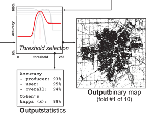
Kotarba A.Z., Nowakowski A. (2018), Impact of snow cover on impervious surface detection. International Journal of Remote Sensing, doi:10.1080/01431161.2018.1475775
Traditionally, snow cover has been seen as an obstacle to landcover classification and impervious surface detection based on remote sensing. However, snow cover increases the spectral contrast between impermeable surfaces and other land-use types.
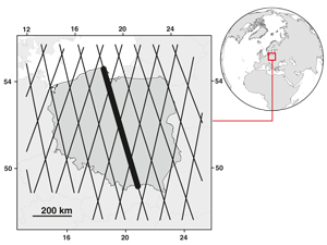
Kotarba A.Z., Vertical profile of cloud amount over Poland: variability and uncertainty based on CloudSat-CALIPSO observations. International Journal of Climatology, doi:10.1002/joc.5558
Historically, climatologists have found it difficult to access reliable information on cloud vertical structure. This is becaus e both surface-based observers and imaging/sounding satellite sensors have limited capability to report superposed cloud. How-ever, lidar–radar
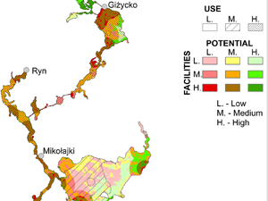
Kulczyk S., Woźniak, E., Derek, M. (2018) Landscape, facilities and visitors: An integrated model of recreational ecosystem services, Ecosystem Services, doi: 10.1016/j.ecoser.2018.02.016
Recreation is a complex and important ecosystem service. Therefore, there is a need for approaches that can account for this complexity, and integrate both environmental and socio-economical perspectives. The Recreational Ecosystem Services (RES) model
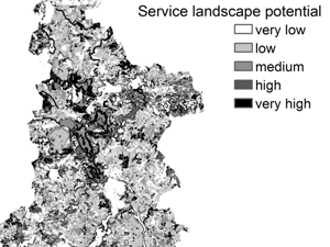
Woźniak E., Kulczyk S., Derek M. (2018) From intrinsic to service potential: An approach to assess tourism landscape potential, Landscape and Urban Planning, 170, 209-220, doi: 10.1016/j.landurbplan.2017.10.006
Tourism contributes to human well-being and is recognized as a cultural ecosystem service. However, assessments of landscape potential for tourism tend to be very general. Therefore, this study proposes a method that takes into
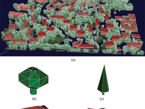
Wajer P., Woźniak E., Kofman W., Rybicki M., Lewiński S. (2018) Simulation of SAR images of urban areas by using the ray tracing method with measured values of backscatter coefficients, International Journal of Remote Sensing, 39:9, 2671-2689, doi: 10.1080/01431161.2018.1430396
This study uses the ray tracing method to simulate synthetic aperture radar (SAR) images of urban areas. The images are constructed for polarisations: horizontal-horizontal (HH) and vertical-vertical (VV), and different types of buildings, vegetation,
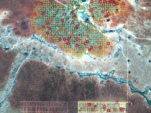
Jenerowicz M., Kemper T. (2016) An improved automated procedure for informal and temporary dwellings detection and enumeration, using mathematical morphology operators on VHR satellite data, Remote Sensing Technologies and Applications in Urban Environments, doi: 10.1117/12.2254808
Every year thousands of people are displaced by conflicts or natural disasters and often gather in large camps. Knowing how many people have been gathered is crucial for an efficient relief operation. However, it