 English version
Lewiński S., Aleksandrowicz S., 2012 “Evaluation of usability of texture inidentifying basic land cover classes on the satellite images of different resolutions” Archiwym Fotogrametrii, Kartografii i Teledetekcji. Vol. 23, 2012, ISBN 978-83-61576-19-8, p
SUMMARY: An attempt was made to trace the possibility of division of the content of satellite images into two basic classes associated with the “low” and “high” values of the texture. This classification approach
Aleksandrowicz S., Lewiński S., Kotarba A., 2012 “Application of IR-MAD transformation to change detection on satellite images” Archiwym Fotogrametrii, Kartografii i Teledetekcji. Vol. 23, 2012, ISBN 978-83-61576-19-8, p. 11-17
ABSTRACT: In the second half of the 1990s, MAD (Multivariate Alteration Detection) method designed for detecting differences in multidimensional datasets was published. It was developed specifically for change detection performed on the basis of

Banaszkiewicz M., Lewiński S., Aleksandrowicz S., Woźniak E., Kotarba A., Krupiński M., “Zastosowanie technik satelitarnych w rolnictwie zrównoważonym, wybrane przykłady zastosowań”, Problemy Inżynierii Rolniczej, 3(77), 109-122, 2012
Satellite remote sensing is one of the main sources of information on natural environment and the processes occurring on the surface of the Earth. Satellite images of different spatial, spectral and radiometric resolution, enable
Drzewiecki W., Wawrzaszek A., Aleksandrowicz S., Krupiński M. 2012. Initial Evaluation of the Applicability of Multifractal Measures as Global Content-Based Image Descriptors. Proc. of ESA-EUSC-JRC 8th Conference on Image Information Mining
Increasing amount of Very High Resolution (VHR) data requires new methods of information mining. In this paper we describe applicability of multifractal theory for VHR panchromatic image analysis. The aim of the study was
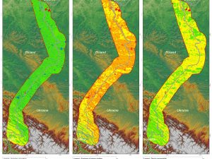
Malinowski, R. Land border monitoring with remote sensing technologies. Proceedings of SPIE – The International Society for Optical Engineering, 2010
The remote sensing technology has many practical applications in different fields of science and industry. There is also a need to examine its usefulness for the purpose of land border surveillance. This research
Lewinski S., Bochenek Z., Turlej K., Application of an Object-Oriented Method for Classification of VHR Satellite Images Using a Rule-Based Approach and Texture Measures, Geoinformation Issues 2010, Vol. 2, no. 1(2), 19-26
New approach for classification of high-resolution satellite images is presented in the article. That approach has been developed at the Institute of Geodesy and Cartography, Warsaw, within the Geoland 2 project – SATChMo Core