 Wersja polska
 English version
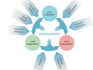
Sobczak-Szelc K. (2024) et al. Navigating environmental fragility: (Mal)coping and adaptation strategies in the socio-environmental system of the Mtendeli Refugee Camp, Tanzania
The study conducts a systems analysis of coping and adaptation strategies in Tanzanian refugee camps, focusing on the Mtendeli camp as a case study. It explores the environmental changes during the stages of the
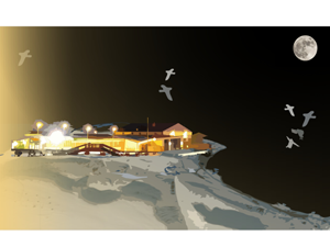
Bałazy K. et al. (2024) Illuminating the Arctic: Unveiling seabird responses to artificial light during polar darkness through citizen science and remote sensing
Artificial light at night (ALAN) has global impacts on animals, often negative, yet its effects in polar regions remains largely underexplored. These regions experience prolonged darkness during the polar night, while human activity and
Domingo-Marimon C. et al. (2024) Developing an early warning land degradation indicator based on geostatistical analysis of Ecosystem Functional Types dynamics
Identifying and quantifying ecosystem degradation and recovery is of critical importance for ecosystem health, biodiversity, food security and the livelihoods of local communities. Remote sensing datasets and techniques, particularly land cover maps, provide crucial
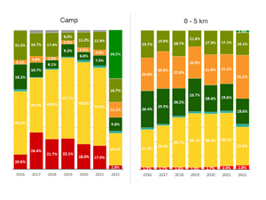
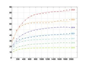
Gromny E. at al., (2024) Remote sensing insights into land cover dynamics and socio-economic Drivers: The case of Mtendeli refugee camp, Tanzania (2016–2022)
The purpose of this article is to present the scope and the dynamics of the environmental changes unfolded in the vicinity of Mtendeli refugee camp. It presents a new method, which combines geospatial analysis
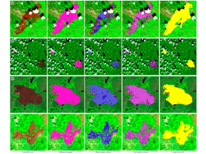
Milczarek, M., at al (2023). Object- Versus Pixel-Based Unsupervised Fire Burn Scar Mapping under Different Biogeographical Conditions in Europe
Wildfire detection and mapping is crucial for managing natural resources and preventingfurther environmental damage. In this study, we compared two methods of mapping burn scarsusing Sentinel-2 satellite imagery, a pixel-based approach and an object-based