 Wersja polska
 English version
Krupiński M., Wawrzaszek A., Drzewiecki W., Aleksandrowicz S., Jenerowicz M. (2019), Multifractal Parameters for Spectral Profile Description, IGARSS 2019
Hyperspectral data provides huge amount of detailed information about spectral properties of the objects. In the era of fast data volume enlargement, it is necessary to develop methods and algorithms which are capable for
Aleksandrowicz S., Wawrzaszek A., Jenerowicz M., Drzewiecki W. and Krupiński M. (2019), Local Multifractal Description of Bi-Temporal VHR Images, 2019 10th International Workshop on the Analysis of Multitemporal Remote Sensing Images (MultiTemp), Shanghai, China, 2019, pp. 1-3. doi: 10.1109/Multi-Temp.2019.8866963
In this work we apply local multifractal formalism to spectral bands of bi-temporal Very High Resolution (VHR) images. Analysis of the local multifractal description and its changes between images acquired in two points in
Jenerowicz M., Wawrzaszek A., Krupiński M., Drzewiecki W., Aleksandrowicz S. (2019), Aplicability of Multifractal Features as Descriptors of the Complex Terrain Situation in IDP/Refugee Camps, IGARSS 2019
This paper presents the preliminary results of the complex terrain situation description with the utility of multifractal features. The analysis was done for two samples of Internally Displaced Person/Refugee camps (Ifo, Daadab in Kenya/Al
Gromny E., Lewiński S., Rybicki M., Malinowski R., Krupiński M., Nowakowski A., and Jenerowicz M. (2019), Creation of training dataset for Sentinel-2 land cover classification, Proc. SPIE
Supervised classification of satellite images is performed based on utilization of reference training data. Therefore, the availability and quality of reference data highly influences the results and the course of the entire classification process.
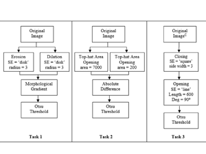
Jenerowicz M., Wawrzaszek A., Krupiński M., Aleksandrowicz S., and Drzewiecki W. (2019), Comparison of mathematical morphology with the local multifractal description applied to the image samples processing, Proc. SPIE
This paper presents the results of a preliminary comparison of two methods which are based on the mathematical approach, Mathematical Morphology and the Local Multifractal Description. Both methods are characterized by the need for
Gromny E., Lewiński S., Rybicki M., Malinowski R., Krupiński M., and Nowakowski A. (2019), Post-processing tools for land cover classification of Sentinel-2, Proc. SPIE
Post-processing is the last and often optional stage of land cover (LC) classification from satellite images. In the traditional approach, it is usually applied to remove the effect of “salt and pepper” from the
Krupiński M., Lewiński S., Malinowski R. (2019), One class SVM for building detection on Sentinel-2 images, Proc. SPIE
Human population has reached 7.7 billion in year 2019. According to the forecasts of world population projections it may reach 8 billion in 2023. This growth indicates inter alia increased demand for housing. Monitoring
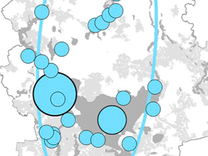
Derek M., Woźniak E., Kulczyk S. (2019), Clustering nature-based tourists by activity. Social, economic and spatial dimensions, Tourism Management
This study develops a typology of tourists visiting a nature-based destination as a function of outdoor activities. It then identifies social, economic and spatial differences between them. A cluster analysis is applied to survey
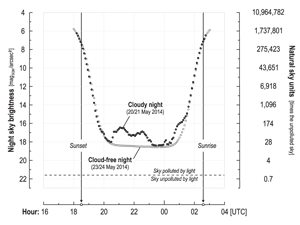
Kotarba A. Z., Chacewicz S., Żmudzka E. (2019), Night sky photometry over Warsaw (Poland) evaluated simultaneously with surface-based and satellite-based cloud observations, Journal of Quantitative Spectroscopy & Radiative Transfer
Light pollution is a widely distributed form of anthropogenic pollution that threatens both biodiversity and human health. One of the most popular indicators is known as night sky brightness (NSB), mea- sured with photometric
MaiL – Identifying Marginal Lands in Europe and strengthening their contribution potentialities in a CO2 sequestration strategy. Globalne zmiany klimatu są problemem światowym, a sposoby radzenia sobie z nimi stały się nawet jednym z