 Wersja polska
 English version
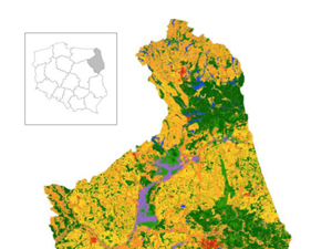
Arslan A. N. et al. (2021), Developing Support for Monitoring and Reporting of GHG Emissions and Removals from Land Use, Land Change and Forestry
This paper presents plans and efforts on European Union (EU) Member States (MSs) (including Norway and Iceland)-specific support for monitoring emissions and removals from land use, land use change and forestry (LULUCF) which are
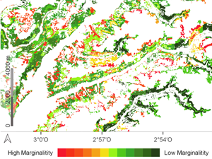
Torralba J., Ruiz L. Á., Georgiadis C., Patias P., Gómez-Conejo R., Verde N., Tassapoulou M., Bezares Sanfelip F., Grommy E., Aleksandrowicz S., Krätzschmar E., Krupiński M., Carbonell-Rivera J. P. (2021), Methodological proposal for the identification of marginal lands with remote sensing-derived products and ancillary data
The concept of marginal land (ML) is dynamic and depends on various factors related to the environment, climate, scale,culture, and economic sector. The current methods for identifying ML are diverse, they employ multiple parameters
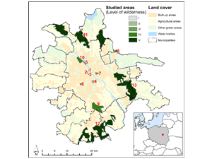
Grzyb T., Kulczyk S., Derek M., Woźniak E. (2021), Using social media to assess recreation across urban green spaces in times of abrupt change
For most of the world’s population, urban green spaces (UGS) offer the easiest form of contact with nature. Such environments deliver a wide variety of Recreational Ecosystem Services (RES) to visitors. This paper explores
Aleksandrowicz S., Wawrzaszek A., Drzewiecki W. Krupiński M., Jenerowicz M. (2021), Change Detection in Multispectral VHR Images Using Spatialized Hölder Exponent
Multifractals have proven to be a valuable tool in image analysis applications and remote sensing (RS). They can be used for image segmentation, texture analysis, and classification. This study explores their applicability to change
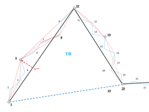
Barańska A., Bac-Bronowicz J., Dejniak D., Lewiński S., Krawczyk A., Chrobak T. (2021), A Unified Methodology for the Generalisation of the Geometry of Features
The development of generalisation (simplification) methods for the geometry of features in digital cartography in most cases involves the improvement of existing algorithms without their validation with respect to the similarity of feature geometry
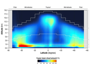
Kotarba A. Z., Solecki M. (2021), Uncertainty Assessment of the Vertically-Resolved Cloud Amount for Joint CloudSat–CALIPSO Radar–Lidar Observations
The joint CloudSat–Cloud-Aerosol Lidar and Infrared Pathfinder Satellite Observation (CALIPSO) climatology remains the only dataset that provides a global, vertically-resolved cloud amount statistic. However, data are affected by uncertainty that is the result of
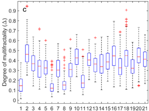
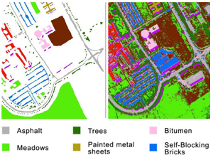
Wawrzaszek A., Drzewiecki W., Krupiński M., Jenerowicz M., Aleksandrowicz S. (2021), Multifractal Features for Land Use Classification
In our work, we analyze multifractal parameters for the description and classification of a 2056 subsets of aerial images representing 21 land-use classes. In particular, we consider the degree of multifractality, estimated with different
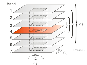
Krupiński M., Wawrzaszek A., Drzewiecki W., Jenerowicz M., Aleksandrowicz S. (2021), Multifractal Parameters for Classification of Hyperspectral Data
(Multi)fractal character of hyperspectral imagery allows for application of new methods and parameters for data processing. In this work we apply Multifractal Detrended Fluctuation Analysis to describe the complex shape of spectral curve and
Nguyen Huu Ż, Kotarba A. Z. (2021), Reliability of visual detections of cirrus over Poland
Earth is a cloudy planet—at every moment, 62–72% of the planet is covered by cloud. Its presence and properties affect the flow of energy between the sun, Earth and the atmosphere. More comprehensive information