 Wersja polska
 English version
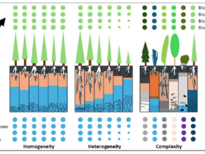
Beierkuhnlein C. (2025) et al. Towards a comprehensive geodiversity – biodiversity nexus in terrestrial ecosystems
The study address the need for an integrated approach to managing complex natural systems by linking geodiversity and biodiversity. These elements interact across scales, influencing climate and human land use while underpinning ecosystem services.
Sobczak-Szelc K. (2024) et al. Navigating environmental fragility: (Mal)coping and adaptation strategies in the socio-environmental system of the Mtendeli Refugee Camp, Tanzania
The study conducts a systems analysis of coping and adaptation strategies in Tanzanian refugee camps, focusing on the Mtendeli camp as a case study. It explores the environmental changes during the stages of the
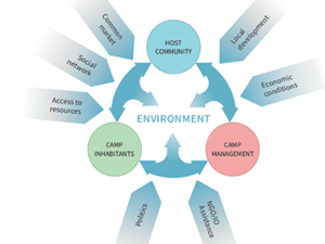
Domingo-Marimon C. et al. (2024) Developing an early warning land degradation indicator based on geostatistical analysis of Ecosystem Functional Types dynamics
Identifying and quantifying ecosystem degradation and recovery is of critical importance for ecosystem health, biodiversity, food security and the livelihoods of local communities. Remote sensing datasets and techniques, particularly land cover maps, provide crucial
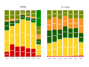
Gromny E. at al., (2024) Remote sensing insights into land cover dynamics and socio-economic Drivers: The case of Mtendeli refugee camp, Tanzania (2016–2022)
The purpose of this article is to present the scope and the dynamics of the environmental changes unfolded in the vicinity of Mtendeli refugee camp. It presents a new method, which combines geospatial analysis
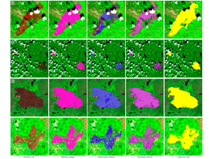
Milczarek, M., at al (2023). Object- Versus Pixel-Based Unsupervised Fire Burn Scar Mapping under Different Biogeographical Conditions in Europe
Wildfire detection and mapping is crucial for managing natural resources and preventingfurther environmental damage. In this study, we compared two methods of mapping burn scarsusing Sentinel-2 satellite imagery, a pixel-based approach and an object-based
EOTiST project during IALE 2022 European Landscape Ecology Congress
Results of EOTiST project will be presented during he biggest European landscape ecology conference – IALE 2022. The conference will take place between 11 and 15 of July 2022. The list of presentations with
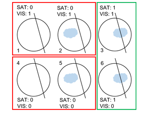
Nguyen Huu Ż, Kotarba A. Z. (2021), Reliability of visual detections of cirrus over Poland
Earth is a cloudy planet—at every moment, 62–72% of the planet is covered by cloud. Its presence and properties affect the flow of energy between the sun, Earth and the atmosphere. More comprehensive information
ARICA
ARICA: Wielokierunkowa analiza obszaru obozów dla uchodźców/osób wewnętrznie przesiedlonych w oparciu o dane satelitarne HR/VHR Zarówno katastrofy naturalne, jak i humanitarne skutkują masowymi przesiedleniami ludności dotkniętej katastrofą. Problem stałego wzrostu liczby uchodźców / osób
- 1
- 2