 Wersja polska
Stelmaszczuk, M., Drzewiecki, W. & Bielecki, M. (2010). Upowszechnianie wykorzystania informacji przestrzennej – propozycja specjalistycznego geoportalu. Polskie Towarzystwo Informacji Przestrzennej Roczniki Geomatyki. 6, 42, 121–130
W ciągu ostatnich trzydziestu lat Unia Europejska wraz z Europejską Agencją Kosmiczną podjęła znaczące wysiłki na rzecz badań i rozwoju w zakresie monitoringu Ziemi, czego efektem jest powstała dwanaście lat temu idea stworzenia programu
Aleksandrowicz S., Stelmaszczuk M., Bochenek Z., Lewiński S., Turlej K., Groom A., Metz A., Esch T., Gurova E., Vaitkus G., 2010. „Seasonal & Annual Change Monitoring” in Photonics Applications in Astronomy, Communications, Industry, and High-Energy Physi
Seasonal & Annual Change Monitoring (SATChMo) is one of the Core Mapping Services within the geoland2 project. The project is co-founded by the European Commission under the 7th Framework Program in the Space Activity
Jenerowicz M., Kemper T., Pesaresi M., Soille P. “Post-event damage assessment using morphological methodology on 0.5m resolution satellite data.”Italian Journal of Remote Sensing – 2010, 42(3)
ASTRACT: This paper presents the results of the application of mathematical morphology techniques for a semi-automatic quantification of the number of dwellings in an IDP camp in Sri Lanka. The specific assessment was undertaken
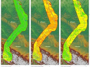
Malinowski, R. Land border monitoring with remote sensing technologies. Proceedings of SPIE – The International Society for Optical Engineering, 2010
The remote sensing technology has many practical applications in different fields of science and industry. There is also a need to examine its usefulness for the purpose of land border surveillance. This research started
Lewinski S., Bochenek Z., Turlej K., Application of an Object-Oriented Method for Classification of VHR Satellite Images Using a Rule-Based Approach and Texture Measures, Geoinformation Issues 2010, Vol. 2, no. 1(2), 19-26
New approach for classification of high-resolution satellite images is presented in the article. That approach has been developed at the Institute of Geodesy and Cartography, Warsaw, within the Geoland 2 project – SATChMo Core