 Wersja polska
 English version
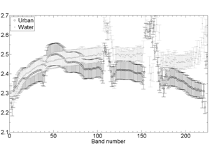
Krupiński M., Wawrzaszek A., Drzewiecki W., Aleksandrowicz S. (2014) Usefulness of the fractal dimension in the context of hyperspectral data description, SGEM2014 Conference Proceedings, ISBN 978-619-7105-12-4 / ISSN 1314-2704, June 19-25, 2014, Book 2, Vol. 3, 367-374 pp
The number of hyperspectral sensors and data grows systematically and dynamically. Hyperspectral data delivers huge number of precise information but character of data requires specific methods of processing. One of these methods can be

Drzewiecki W., Jenerowicz M., Aleksandrowicz S., Krupiński M. Spatial Modeling of Potential Ways of Crossing the Borders by Illegal Immigrants. Annals of Geomatics 2012, t.10 z4, pp 49-64
One of the main objectives of geographical information systems is to support the process of decision making. Spatial modeling can be a useful tool to provide such support also for the analyses of general
Krupiński M., Drzewiecki W., Wawrzaszek A., Aleksandrowicz S. Initial Evaluation of the Applicability of Multifractal Measures as Global Content-Based Image Descriptors. ESA-EUSC-JRC 8th conference on image information mining; 10/2013
Increasing amount of Very High Resolution (VHR) data requires new methods of information mining. In this paper we describe applicability of multifractal theory for VHR panchromatic image analysis. The aim of the study was
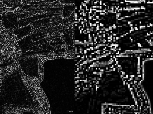
Testing Texture of VHR Panchromatic Data as a Feature of Land Cover Classification
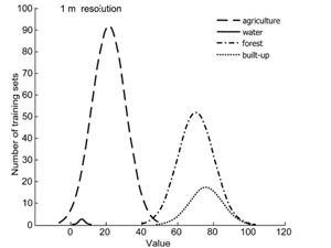
While it is well-known that texture can be used to classify very high resolution (VHR) data, the limits of its applicability have not been unequivocally specified. This study examines whether it is possible to
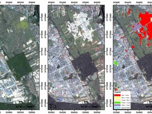
Change Detection Algorithm for the Production of Land Cover Change Maps over the European Union Countries
Contemporary satellite Earth Observation systems provide growing amounts of very high spatial resolution data that can be used in various applications. An increasing number of sensors make it possible to monitor selected areas in

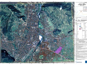
ADEMOS
The goal of this project is to improve the dwellings detection methodology and to develop an operational stand-alone application in order to provide reliable and consistent results, independent of the imaging sensors type and
AF3
In recent years, the frequency of large-scale forest fires has increased significantly owing to a number of factors including the effects of climate change, urbanisation, poor landscape management and malevolent acts. These so-called “Mega-fires”

EDEN 2015 Exercise
On April 13-15th, 2015, by Tarnobrzeskie Lake and on the terrain of Siarkopol Chemical Factories, there was held Regional Fire Service Exercise. The main aim of the exercise was to examine the quality of
Earthquake in Nepal
On April 25, 2015 an earthquake of magnitude 7,9 on the Richter scale struck densely populated areas of Nepal. Crisis Information Centre SRC PAS monitors maps which are being created and supplies Polish Center
Lewiński S., Aleksandrowicz S., Banaszkiewicz M. (2015) Testing Texture of VHR Panchromatic Data as a Feature of Land Cover Classification, Acta Geophysica, Volume 63, Issue 2, pp 547–567, doi: 10.2478/s11600-014-0250-5
While it is well-known that texture can be used to classify very high resolution (VHR) data, the limits of its applicability have not been unequivocally specified. This study examines whether it is possible to