 Wersja polska
 English version
Stelmaszczuk, M., Drzewiecki, W. & Bielecki, M. (2010). Capacity building in the usage of spatial information – proposition of the specialized geoportal. Annals of Geomatics of the Polish Association for Spatial Information, 6, 42, 121–130
The Earth Observation sector evolves rapidly. This fact provides motivation for organisations from all over the world to undertake different initiatives and programs aimed at improving the management of EO resourses. One of them
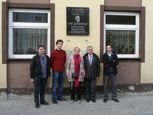
IV Space Conference in Sieradz
On 8-9 October 2013 in Cultural Center in Sieradz held IV Space Conference “Heritage Arego Sternfeld. Earth as seen from outer space.”. This conference was organized in honor of Arego Sternfeld- one of the
EOPOWER: Earth Observation for Economic Empowerment
The purpose of the EOPOWER project is to create conditions for sustainable economic development through the increased use of Earth observation products and services for environmental applications. This purpose serves the higher goal of
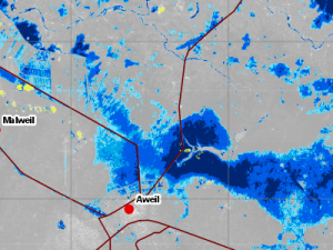
Crisis Information Centre in fight against floods in South Sudan
As every year since August until October, the area surrounding rivers Lol and Jur in South Sudan is visited by floods caused by torrential rainfalls that occurs during the rainy season. The swollen rivers
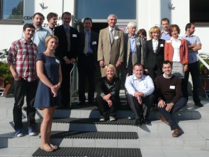
Polish-Ukrainian seminar
Earth Observation Group as part of the EOPOWER project, has organized a seminar, which was attended by representatives of scientific institutions and NGOs from Poland and Ukraine, i.e. Scientific Centre for Aerospace Research of
Aleksandrowicz S., Stelmaszczuk M., Bochenek Z., Lewiński S., Turlej K., Groom A., Metz A., Esch T., Gurova E., Vaitkus G., 2010. “Seasonal & Annual Change Monitoring” in Photonics Applications in Astronomy, Communications, Industry, and High-Energy Physi
Seasonal & Annual Change Monitoring (SATChMo) is one of the Core Mapping Services within the geoland2 project. The project is co-founded by the European Commission under the 7th Framework Program in the Space Activity
Gromek A., Jenerowicz M. “SAR imagery change detection method for Land Border Monitoring” 6th International Workshop Analysis of Multi-temporal Remote Sensning Images, In Proc. of MultiTemp 2011, p 213-216, Print ISBN: 978-1-4577-1202-9, DOI: 10.1109/Multi-Temp.2011.6005086
ABSTRACT: Change detection is the process of identifying differences that have occurred in the terrain situation at different times. The Earth Observation (EO) data contribute to obtain the rapid and reliable change detection information
Jenerowicz M., Kemper T., Soille T. “An automated procedure for detection of IDP’s dwellings using VHR satellite imagery” In Proc. of SPIE – Image Signal processing for Remote Sensing XVII, Vol. 8180 (SPIE, Bellingham, WA 2011), 818004
ABSTRACT: This paper presents the results for the estimation of dwellings structures in Al Salam IDP Camp, Southern Darfur, based on Very High Resolution multispectral satellite images obtained by implementation of Mathematical Morphology analysis.
Kemper T., Jenerowicz M., Pesaresi M., Soille P. “Enumeration of dwellings in Darfur camps from GeoEye-1 satellite image using mathematical morphology”. IEE Journal of selected topics in applied Earth Observations and Remote Sensing, Vol. 4, No. 1, March
This paper presents a methodology for the detection of dwelling structures in Darfur camps to estimate the total number of dwellings per camp using GeoEye-1 satellite images. The method is based on a translation
Kemper T., Jenerowicz M., Gueguen L., Poli D., Soille P. “Monitoring changes in the Menik Farm IDP camps in Sri Lanka using multi-temporal very high resolution satellite data”. International Journal of Digital Earth. Taylor&Francis Group, print ISSN 1753 – 8947
ABSTRACT: This paper presents the results of the application of mathematical morphology for the automatic quantification of the number of tents and the detection of changes in the Menik Farm IDP camp in Sri