 Wersja polska
 English version
Woźniak E., Kofman W., Wajer P., Lewiński S., Nowakowski A. (2016) The influence of filtration and decomposition window size on the thresholdvalue and accuracy of land-cover classification of polarimetric SAR images, International Journal of Remote Sensing, 37:1, 212-228, doi: 10.1080/01431161.2015.1125548
In this study we use ALOS PALSAR satellite data to classify land cover using a decision tree algorithm. We apply polarimetric decomposition methods to coherence and covariance matrices obtained from the data and then
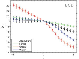
Aleksandrowicz, S.; Wawrzaszek, A.; Drzewiecki, W.; Krupiński, M. (2016) Change Detection Using Global and Local Multifractal Description, IEEE Geoscience and Remote Sensing Letters, Volume: 13, Issue: 8, Aug. 2016, doi: 10.1109/LGRS.2016.2574940
In this letter, we apply the multifractal formalism to land cover change detection on very high spatial resolution data. Specifically, multifractal spectra are determined and, with modifications, are used as an initial general indicator
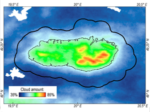
Kotarba A.Z. (2016) Comparison of Differences Between MODIS 250 m and 1 km Cloud Masks. Atmospheric Research, 181, 54-62, doi:10.1016/j.atmosres.2016.06.014
The spatial resolution of remote sensing instruments installed onboard satellites is one of the key factors for accurate estimations of cloud amount. In general terms, the larger the instantaneous field of view (IFOV), the
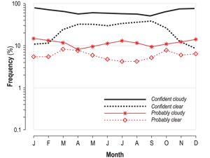
Kotarba A.Z. (2017) Inconsistency of surface-based (SYNOP) and satellite-based (MODIS) cloud amount estimations due to the interpretation of cloud detection results. International Journal of Climatology, 37, 4092-4104, doi:10.1002/joc.5011
Surface-based and satellite-based observations remain the fundamental source of cloud amount data for climatologists. However, both data sets show inconsistency related to the interpretation of instantaneous cloud detection, whether measured using the okta scale

24th SPIE Remote Sensing Symposium in Warsaw
We cordially invite you to participate in the 2017 SPIE Remote Sensing symposium. Over the past 23 years SPIE Remote Sensing has become the largest and most prestigious annual international meeting on this subject
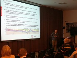
Seminar of the Remote Sensing Section
On 14th December 2016 seminary of the Remote Sensing Section, which is part of the Space and Satellite Research Committee, took place. The main subject of the 4th seminar was “Transformation and acquisition of
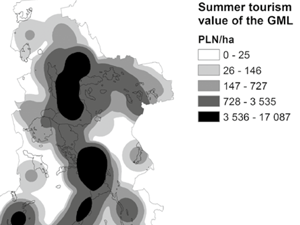
Kulczyk S., Woźniak E., Derek M., Kowalczyk M. (2016) How much is the “wonder of nature” worth? The valuation of tourism in the Great Masurian Lakes using travel cost method, Ekonomia i Środowisko, V.4 Nr.59
Although natural values are crucial for most of outdoor activities, they are rarely included into tourism accounts. Balmford et al.1 estimate the global value of tourism in natural protected areas as USD 600 billion
Drzewiecki W., Wawrzaszek A., Krupiński M., Aleksandrowicz S., Bernat K. (2016) Applicability of multifractal features as global characteristics of WorldView-2 panchromatic satellite images, European Journal of Remote Sensing, 49:1, 809-834, doi: 10.5721/EuJRS20164943
In this work we analyse fractal and multifractal characteristics for description and extraction of information from VHR satellite images. We propose the degree of multifractality as a global descriptor of satellite image content and
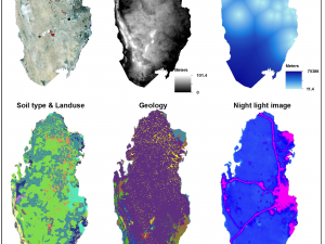
Peng Y., Kheir R.B., Adhikari K., Malinowski R., Greve M.B., Knadel M., Greve, M.H. (2016) Digital Mapping of Toxic Metals in Qatari Soils Using Remote Sensing and Ancillary Data. Remote Sensing, 8, 1003, doi:10.3390/rs8121003
After decades of mining and industrialization in Qatar, it is important to estimate their impact on soil pollution with toxic metals. The study utilized 300 topsoil (0–30 cm) samples, multi-spectral images (Landsat 8), spectral
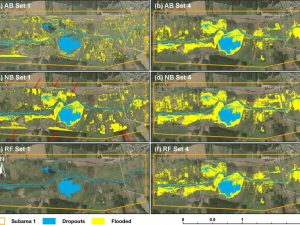
Malinowski R., Höfle B., Koenig K., Groom G., Schwanghart W., Heckrath G. (2016) Local-scale flood mapping on vegetated floodplains from radiometrically calibrated airborne LiDAR data. ISPRS Journal of Photogrammetry and Remote Sensing 2016, 119, 267-279, doi: 10.1016/j.isprsjprs.2016.06.009
Knowledge about the magnitude of localised flooding of riverine areas is crucial for appropriate land management and administration at regional and local levels. However, detection and delineation of localised flooding with remote sensing techniques