 Wersja polska
Marcin Rybicki Archive
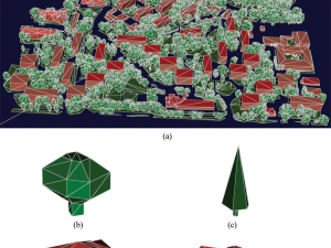
Wajer P., Woźniak E., Kofman W., Rybicki M., Lewiński S. (2018) Simulation of SAR images of urban areas by using the ray tracing method with measured values of backscatter coefficients, International Journal of Remote Sensing, 39:9, 2671-2689, doi: 10.1080/01431161.2018.1430396
This study uses the ray tracing method to simulate synthetic aperture radar (SAR) images of urban areas. The images are constructed for polarisations: horizontal-horizontal (HH) and vertical-vertical (VV), and different types of buildings, vegetation,
Kukawska E. et al. (2017) Multitemporal Sentinel-2 data – remarks and observations. 9th International Workshop on the Analysis of Multitemporal Remote Sensing Images (MultiTemp), Brugge, 2017, pp. 1-4, doi: 10.1109/Multi-Temp.2017.8035212
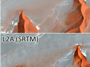
All the pre-processing algorithms are being improved constantly. The biggest challenge for the multitemporal analysis is to deal with errors caused directly by the chain of pre-processing of raw Sentinel-2 data to the level
Lewiński S., Nowakowski A., Malinowski R., Rybicki M., Kukawska E., Krupiński M. (2017) Aggregation of Sentinel-2 time series classifications as a solution for multitemporal analysis. In Proc. SPIE 10427, Image and Signal Processing for Remote Sensing XXIII, 104270B doi: 10.1117/12.2277976
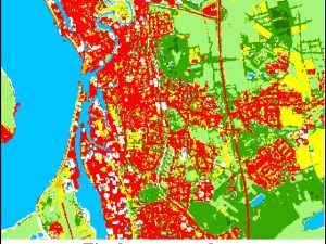
The general aim of this work was to elaborate efficient and reliable aggregation method that could be used for creating a land cover map at a global scale from multitemporal satellite imagery. The study