 Wersja polska
 English version
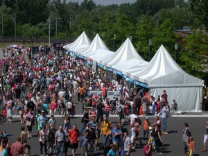
EOG at 17th Science Picnic
On 15 June 2013 our team participated in 17. Science Picnic organized by Polish Radio and Copernicus Science Centre. Our stand was visited by many people interested in processing of satellite images. Main

Jenerowicz M., Kemper T., Pesaresi M., Soille P. “Post-event damage assessment using morphological methodology on 0.5m resolution satellite data.”Italian Journal of Remote Sensing – 2010, 42(3)
ASTRACT: This paper presents the results of the application of mathematical morphology techniques for a semi-automatic quantification of the number of dwellings in an IDP camp in Sri Lanka. The specific assessment was undertaken
Kemper T., Jenerowicz M., Soille P. “Counting people in refugee/IDP camps in Darfur/Sudan: what error is acceptable?”, Proc. of VALgEO 2009, European Comission, Joint Research Centre, pp. 153-155
INTRO: According to the United Nations High Commissioner for Refugees, the forced population displacement has grown in size and complexity in recent years; there were approx. 42 million forcibly displaced people worldwide at the
Lewiński S., Sotnikov O., Krupiński M., Parshyna O., Dąbrowski R., 2012. “Satellite images SICH-2 – first analysis”. Archiwum Fotogrametrii, Kartografii i Teledetekcji Vol. 24, 2012, ISBN 978-83-61576-22-8 , p. 177 – 186
Ukrainian-Russian carrier rocket Dnepr, that was launched on August 17, 2011 from the Baikonur Dombarowskij in Russia, has placed in orbit the Sich-2 satellite. It is a satellite dedicated to Earth observation, designed and
Stopa K., Nowakowski A., 2012. “MatSIM – automatic satellite image matching based on spatial features analysis” Archiwym Fotogrametrii, Kartografii i Teledetekcji. Vol. 24, 2012, ISBN 978-83-61576-22-8, p. 357 – 366.
ABSTRACT: Image geometrization is one of the basic processes in satellite image processing. As a result ofthe transformations performed, georeference is attached to the image becoming a cartometric image. Depending of the used algorithm,
Lewiński S., Aleksandrowicz S., 2012 “Evaluation of usability of texture inidentifying basic land cover classes on the satellite images of different resolutions” Archiwym Fotogrametrii, Kartografii i Teledetekcji. Vol. 23, 2012, ISBN 978-83-61576-19-8, p
SUMMARY: An attempt was made to trace the possibility of division of the content of satellite images into two basic classes associated with the “low” and “high” values of the texture. This classification approach
Aleksandrowicz S., Lewiński S., Kotarba A., 2012 “Application of IR-MAD transformation to change detection on satellite images” Archiwym Fotogrametrii, Kartografii i Teledetekcji. Vol. 23, 2012, ISBN 978-83-61576-19-8, p. 11-17
ABSTRACT: In the second half of the 1990s, MAD (Multivariate Alteration Detection) method designed for detecting differences in multidimensional datasets was published. It was developed specifically for change detection performed on the basis of

Banaszkiewicz M., Lewiński S., Aleksandrowicz S., Woźniak E., Kotarba A., Krupiński M., “Zastosowanie technik satelitarnych w rolnictwie zrównoważonym, wybrane przykłady zastosowań”, Problemy Inżynierii Rolniczej, 3(77), 109-122, 2012
Satellite remote sensing is one of the main sources of information on natural environment and the processes occurring on the surface of the Earth. Satellite images of different spatial, spectral and radiometric resolution, enable
Drzewiecki W., Wawrzaszek A., Aleksandrowicz S., Krupiński M. 2012. Initial Evaluation of the Applicability of Multifractal Measures as Global Content-Based Image Descriptors. Proc. of ESA-EUSC-JRC 8th Conference on Image Information Mining
Increasing amount of Very High Resolution (VHR) data requires new methods of information mining. In this paper we describe applicability of multifractal theory for VHR panchromatic image analysis. The aim of the study was
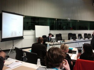
GEONetCab final workshop
On 23 April in Brussels was held the workshop ‘Risk and environment management: the added value of satellite applications’, hosted by the Committee of the Regions, and organised by Eurisy in cooperation with the