 Wersja polska
 English version
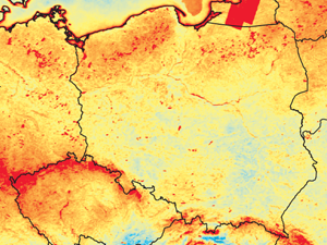
Kotarba A.Z. (2016) Regional high-resolution cloud climatology based on MODIS cloud detection data, Volume 36, Issue 8 30 June 2016 Pages 3105–3115, doi: 10.1002/joc.4539
Most satellite cloud climatologies come in the form of global, low-resolution datasets: so- called ‘gridded’ Level 3 products, resulting from the reprojection and spatio-temporal aggregation of swath (Level 2) data. Their coarse resolution means
Wawrzaszek A., Walichnowska M., Krupiński M., (2015) Ocena przydatności poziomu multifraktalności do opisu wysokorozdzielczych danych pozyskanych przez satelity Landsat, Archiwum Fotogrametrii, Kartografii i Teledetekcji 2015, vol. 27, s. 175-184 ISSN 2083-2214, eISSN 2391-9477, doi: 10.14681/afkit.2015.013
W ramach pracy przeanalizowano 6 scen o trzydziestometrowej rozdzielczości pochodzące z satelitów Landsat 5, 7 i 8, zarejestrowane w sześciu zakresach długości fali i prezentujące obszar Warszawy. Stosując dwa algorytmy podziału dużych scen –
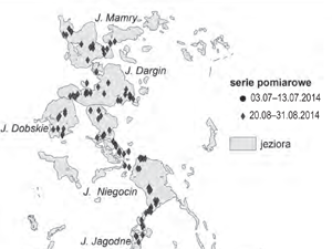
Kulczyk S.,Woźniak E. , Derek M. , Kowalczyk M. (2015) Pomiar marszrutowy jako narzędzie monitoringu aktywności turystycznej. Przykład Wielkich Jezior Mazurskich. Problemy Ekologii Krajobrazu, T. XXXIX, 111–119
In order to describe relations between tourism and landscape, it is important to operate within two scopes. The first is landscape potential and the second – the way it is used by tourists. In
Nowakowski A. (2015) Remote Sensing Data Binary Classification Using Boosting with Simple Classifiers, Acta Geophys. (2015) 63: 1447, doi: 10.1515/acgeo-2015-004
Boosting is a classification method which has been proven useful in non-satellite image processing while it is still new to satellite remote sensing. It is a meta-algorithm, which builds a strong classifier from many
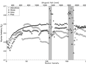
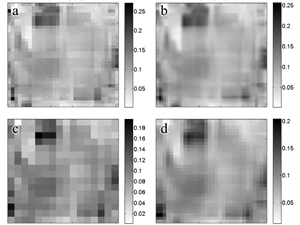
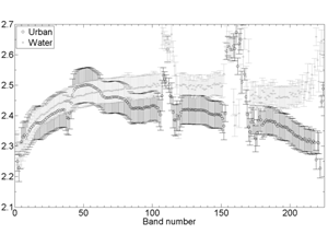
Wawrzaszek A., Krupiński M., Drzewiecki W., Aleksandrowicz S. (2015) Multifraktalna analiza zobrazowań satelitarnych , Archiwum Fotogrametrii, Kartografii i Teledetekcji 2015, vol. 27, s. 163-173 ISSN 2083-2214, eISSN 2391-947, doi: 10.14681/afkit.2015.012
Przedstawione prace badawcze dotyczyły oceny skuteczności stosowania opisu multifraktalnego jako narzędzia do wydobywania informacji z bardzo wysokorozdzielczych zobrazowań satelitarnych, prezentujących głównie obszary Polski. Przeanalizowano duże zestawy danych panchromatycznych, zarejestrowanych przez satelity WorldView-2 i EROS-A.
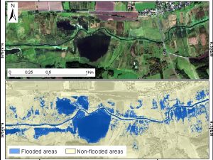
Malinowski R., Groom G., Schwanghart W., Heckrath G. (2015) Detection and delineation of localized flooding from worldview-2 multispectral data. Remote Sensing 2015, 7, 14853-14875, doi: 10.3390/rs71114853
Remote sensing technology serves as a powerful tool for analyzing geospatial characteristics of flood inundation events at various scales. However, the performance of remote sensing methods depends heavily on the flood characteristics and landscape
Krupiński M., Wawrzaszek A., Drzewiecki W., Aleksandrowicz S. (2014) Usefulness of the fractal dimension in the context of hyperspectral data description, SGEM2014 Conference Proceedings, ISBN 978-619-7105-12-4 / ISSN 1314-2704, June 19-25, 2014, Book 2, Vol. 3, 367-374 pp
The number of hyperspectral sensors and data grows systematically and dynamically. Hyperspectral data delivers huge number of precise information but character of data requires specific methods of processing. One of these methods can be

Drzewiecki W., Jenerowicz M., Aleksandrowicz S., Krupiński M. Spatial Modeling of Potential Ways of Crossing the Borders by Illegal Immigrants. Annals of Geomatics 2012, t.10 z4, pp 49-64
One of the main objectives of geographical information systems is to support the process of decision making. Spatial modeling can be a useful tool to provide such support also for the analyses of general
Krupiński M., Drzewiecki W., Wawrzaszek A., Aleksandrowicz S. Initial Evaluation of the Applicability of Multifractal Measures as Global Content-Based Image Descriptors. ESA-EUSC-JRC 8th conference on image information mining; 10/2013
Increasing amount of Very High Resolution (VHR) data requires new methods of information mining. In this paper we describe applicability of multifractal theory for VHR panchromatic image analysis. The aim of the study was
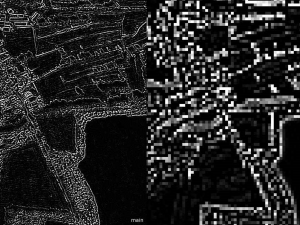
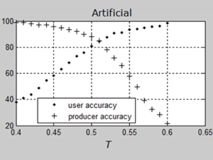
Testing Texture of VHR Panchromatic Data as a Feature of Land Cover Classification
While it is well-known that texture can be used to classify very high resolution (VHR) data, the limits of its applicability have not been unequivocally specified. This study examines whether it is possible to