 Wersja polska
 English version
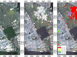
Change Detection Algorithm for the Production of Land Cover Change Maps over the European Union Countries
Contemporary satellite Earth Observation systems provide growing amounts of very high spatial resolution data that can be used in various applications. An increasing number of sensors make it possible to monitor selected areas in
Lewiński S., Aleksandrowicz S., Banaszkiewicz M. (2015) Testing Texture of VHR Panchromatic Data as a Feature of Land Cover Classification, Acta Geophysica, Volume 63, Issue 2, pp 547–567, doi: 10.2478/s11600-014-0250-5
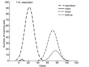
While it is well-known that texture can be used to classify very high resolution (VHR) data, the limits of its applicability have not been unequivocally specified. This study examines whether it is possible to
Kotarba A.Z. (2015) Evaluation of ISCCP cloud amount with MODIS observations, Atmospheric Research, vol. 153, 310-317, doi: 10.1016/j.atmosres.2014.09.006
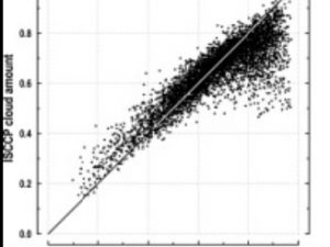
The goal of the International Satellite Cloud Climatology Project (ISCCP) is to provide global cloud amount statistics for atmospheric radiation flux modeling, which is a key element of climate change studies. However, ISCCP estimates

Pyka K.; Drzewiecki W.; Bernat K. ; Wawrzaszek A.; Krupiński M. Usefulness of wavelet-based features as global descriptors of VHR satellite images. Proc. SPIE 9244, Image and Signal Processing for Remote Sensing XX, 92441D (October 13, 2014)
In this paper we present the results of research carried out to assess the usefulness of wavelet-based measures of image texture for classification of panchromatic VHR satellite image content. The study is based on
Wawrzaszek A., Aleksandrowicz S., Krupiński M., Drzewiecki W. Influence of Image Filtering on Land Cover Classification when using Fractal and Multifractal Features. PFG Photogrammetrie, Fernerkundung, Geoinformation Jahrgang 2014 Heft 2 (2014), p.101-115
Over the last years, many features describing satellite images have been proposed. In this paper we analyse and compare fractal and multifractal features in the context of the discrimination of the four most common
European Area Frame Sampling Based on Very High Resolution Images
Initiated in 2007, the Area Frame Sampling Europe subtask of the Seasonal and Annual Change Monitoring Service (SATChMo) Core Service in the geoland2 project delivered its final products in 2012. Three of these are
Drzewiecki W., Wawrzaszek A., Aleksandrowicz S., Krupinski M., Bernat K. Comparison of selected textural features as global content-based descriptors of VHR satellite image. Geoscience and Remote Sensing Symposium (IGARSS), 2013 IEEE International
The paper presents the results of the study of usefulness of selected textural features for describing the content of image chips (1024 by 1024 pixels) cut from WorldView-2 panchromatic images. Several texture analysis techniques
Wawrzaszek A., Krupinski, M. ; Aleksandrowicz S., Drzewiecki W. Fractal and multifractal characteristics of very high resolution satellite images. Geoscience and Remote Sensing Symposium (IGARSS), 2013 IEEE International.
In our work we analyse fractal and multifractal characteristics for description and extraction of information from very high spatial resolution satellite images. In particular, we propose the degree of multifractality as a parameter for
Wawrzaszek A., Krupiński M., Aleksandrowicz S., Drzewiecki W.: Formalizm multifraktalny w analizie zobrazowań satelitarnych. Archiwum Fotogrametrii, Kartografii i Teledetekcji, vol. 25, s.261–272, 2013
W pracy przedstawiamy formalizm multifraktalny, jako narzędzie wspomagające opis i ekstrakcję informacji z wysokorozdzielczych zobrazowań satelitarnych. Podejście to opiera się na założeniu, że na pojedynczy obraz (multifraktal) składa się wiele fraktali, każdy o innym
Drzewiecki W., Wawrzaszek A., Krupiński M., Aleksandrowicz S., Bernat K.: Comparison of selected textural features as global content-based descriptors of VHR satellite image – the EROS-A study. 2013 Federated Conference on Computer Science and Information
Texture is considered as one of the most crucial image features used commonly in computer vision. It is important source of information about image content, especially for single-band images. In this paper we present