 Wersja polska
 English version
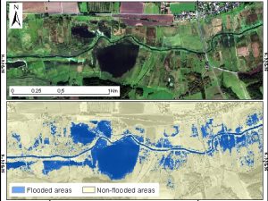
Malinowski, R.; Groom, G.; Schwanghart, W.; Heckrath, G. Detection and delineation of localized flooding from worldview-2 multispectral data. Remote Sensing 2015, 7, 14853-14875.
Remote sensing technology serves as a powerful tool for analyzing geospatial characteristics of flood inundation events at various scales. However, the performance of remote sensing methods depends heavily on the flood characteristics and landscape
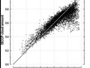
Kotarba A.Z. (2015) Evaluation of ISCCP cloud amount with MODIS observations, Atmospheric Research, vol. 153, 310-317, doi: 10.1016/j.atmosres.2014.09.006
The goal of the International Satellite Cloud Climatology Project (ISCCP) is to provide global cloud amount statistics for atmospheric radiation flux modeling, which is a key element of climate change studies. However, ISCCP estimates
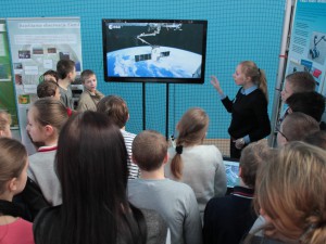
Science picnic “Day of Space Science”
On the 16th February of 2015 in John Paul II Upper Secondary School Complex in Radzyń Podlaski was held science picnic “Day of Space Science”. Space Research Center PAS was a co-organizer of this
Success stories from the EOPOWER project
During the EOPOWER project our group initiated actions which aim was to begin cooperation between Polish and Ukrainian Earth Observation institutions. Unexpectedly, it was also a time of serious political and economical disturbances in

Pyka K.; Drzewiecki W.; Bernat K. ; Wawrzaszek A.; Krupiński M. Usefulness of wavelet-based features as global descriptors of VHR satellite images. Proc. SPIE 9244, Image and Signal Processing for Remote Sensing XX, 92441D (October 13, 2014)
In this paper we present the results of research carried out to assess the usefulness of wavelet-based measures of image texture for classification of panchromatic VHR satellite image content. The study is based on

Portal dedicated to Earth observation sector
Portal was established in the frames of EOPOWER project (Earth Observation for Economic Empowerment) under 7. Frame Programme of European Union. The main aim is to create conditions for sustainable economic development through the increased
Wawrzaszek A., Aleksandrowicz S., Krupiński M., Drzewiecki W. Influence of Image Filtering on Land Cover Classification when using Fractal and Multifractal Features. PFG Photogrammetrie, Fernerkundung, Geoinformation Jahrgang 2014 Heft 2 (2014), p.101-115
Over the last years, many features describing satellite images have been proposed. In this paper we analyse and compare fractal and multifractal features in the context of the discrimination of the four most common
Space App Camp 2014
From 4th to 12th May two of our software developers, Adam Włodarkiewicz and Krzysztof Stopa together with two android developers, Danny Preussler (Grupon) and Johannes Orgis (6Wunderkinder) from Berlin, have been selected to participate

Earth Observation for Gas and Oil: On-shore
This project is dedicated to support European Space Agency and the Oil and Gas Producers EO(OGP EO) sub-committee establish the key geo-information requirement needs of the onshore oil and gas sector throughout the oil
ESA Sentinel 1: Feasibility study of land cover classification based on SAR Sentinel-1 images
The goal of the project is to perform feasibility study of land cover classification based on SAR Sentinel-1 images. Currently used algorithms dedicated to land cover classification on SAR images does not give the