 Wersja polska
 English version
G-SEXTANT: Service Provision of geospatial intelligence in EU External Actions support
G-SEXTANT aims to develop a portfolio of Earth Observation (EO) products and services to support the geo-spatial information needs of EU External Action users and stakeholders, such as the European External Action Service and
G-NEXT: GMES pre-operational security services for supporting external actions
G-NEXT aims to contribute to the transition of the Copernicus services for Security applications from pre-operational to operational mode. In particular, G-NEXT will supply information and intelligence data in support of the European External

SCARF
Cloud cover plays key role in distributing the solar radiation in the atmosphere. The SCARF (Satellite Cloud Climatology over Poland with Atmospheric Radiation Fluxes Estimation) project aims to estimate the fraction cloud cover over
Multifractal Analysis of Satellite Images
This project is supported by the Polish National Science Centre (NCN) and the Ministry of Science and Higher Education (MNiSW) through Grant NN 526 1568 40. The scientific aim of this project is to
Copernicus new official name for GMES
“Copernicus” is the new name for the programe developed by the European Commision knnowed before as GMES (Global Monitoring for Environment and Security). The new name was announced yesterday by the European Commissioner for

SPEKTROP-L
SPEKTROP-L is an extension of the SPEKTROP project (financed before by the Innovative Economy Programme), within which several models and a prototype of a hypercpectral imaging were developed and tested. The prototype was intended
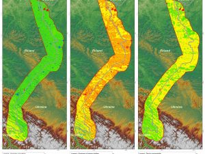
Malinowski, R. Land border monitoring with remote sensing technologies. Proceedings of SPIE – The International Society for Optical Engineering, 2010
The remote sensing technology has many practical applications in different fields of science and industry. There is also a need to examine its usefulness for the purpose of land border surveillance. This research
Lewinski S., Bochenek Z., Turlej K., Application of an Object-Oriented Method for Classification of VHR Satellite Images Using a Rule-Based Approach and Texture Measures, Geoinformation Issues 2010, Vol. 2, no. 1(2), 19-26
New approach for classification of high-resolution satellite images is presented in the article. That approach has been developed at the Institute of Geodesy and Cartography, Warsaw, within the Geoland 2 project – SATChMo Core
GEONetCab
GeoNetCAB – Earth’s satellite imaging is developing very fast. Earth’s observation systems are created worldwide for better management of Earth’s resources. One of the initiatives was the creation of GEO Group on Earth Observations
G-MOSAIC
G-MOSAIC – GMES service for Management of Operations, Situation Awerness and Intelligence for regional Crises. A procejt co-financed by the European Union providing the preparation on information services in the area of external security.